


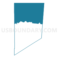
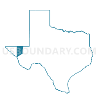
Voting District 03-3, Culberson County, Texas
About
Outline

Summary
| Unique Area Identifier | 671817 |
| Name | Voting District 03-3 |
| County | Culberson County |
| State | Texas |
| Area (square miles) | 1,752.87 |
| Land Area (square miles) | 1,752.80 |
| Water Area (square miles) | 0.07 |
| % of Land Area | 100.00 |
| % of Water Area | 0.00 |
| Latitude of the Internal Point | 31.79550790 |
| Longtitude of the Internal Point | -104.43816710 |
Maps

Graphs
Select a template below for downloading or customizing gragh for Voting District 03-3, Culberson County, Texas


Neighbors
Neighoring Voting District (by Name) Neighboring Voting District on the Map
- Voting District 0001, Hudspeth County, TX
- Voting District 0002, Culberson County, TX
- Voting District 0004, Culberson County, TX
- Voting District 0004, Hudspeth County, TX
- Voting District 0004, Reeves County, TX
- Voting District 0008, Reeves County, TX
- Voting District 03-5, Culberson County, TX
- Eddy County Precinct 29, Eddy County, NM
- Eddy County Precinct 30, Eddy County, NM
- Eddy County Precinct 32, Eddy County, NM
- Otero County Precinct 3, Otero County, NM
Top 10 Neighboring County Subdivision (by Population) Neighboring County Subdivision on the Map
- Carlsbad CCD, Eddy County, NM (33,626)
- Southeast Otero CCD, Otero County, NM (13,108)
- Pecos CCD, Reeves County, TX (12,808)
- Loving CCD, Eddy County, NM (2,179)
- Dell City CCD, Hudspeth County, TX (761)
- Sierra Blanca CCD, Hudspeth County, TX (658)
- Van Horn Rural CCD, Culberson County, TX (209)
Top 10 Neighboring Unified School District (by Population) Neighboring Unified School District on the Map
- Alamogordo Public Schools, NM (43,326)
- Carlsbad Municipal Schools, NM (33,835)
- Pecos-Barstow-Toyah Independent School District, TX (13,521)
- Culberson County-Allamoore Independent School District, TX (2,415)
- Dell City Independent School District, TX (620)
Top 10 Neighboring State Legislative District Lower Chamber (by Population) Neighboring State Legislative District Lower Chamber on the Map
- State House District 74, TX (143,566)
- State House District 54, NM (30,120)
- State House District 55, NM (26,393)
Top 10 Neighboring State Legislative District Upper Chamber (by Population) Neighboring State Legislative District Upper Chamber on the Map
- State Senate District 19, TX (766,044)
- State Senate District 41, NM (48,782)
- State Senate District 34, NM (45,445)
Top 10 Neighboring 111th Congressional District (by Population) Neighboring 111th Congressional District on the Map
Top 10 Neighboring Census Tract (by Population) Neighboring Census Tract on the Map
- Census Tract 9.02, Otero County, NM (9,941)
- Census Tract 7, Eddy County, NM (5,179)
- Census Tract 9501, Reeves County, TX (4,319)
- Census Tract 9503, Hudspeth County, TX (3,476)
- Census Tract 9503, Culberson County, TX (2,398)
- Census Tract 8, Eddy County, NM (2,179)
Top 10 Neighboring 5-Digit ZIP Code Tabulation Area (by Population) Neighboring 5-Digit ZIP Code Tabulation Area on the Map
- 88220, NM (33,725)
- 79772, TX (12,747)
- 79855, TX (2,336)
- 79837, NM (579)
- 88263, NM (175)
- 79847, TX (167)
- 79785, TX (91)
- 79770, TX (33)